Sunday, October 24, 2010

Mt Chocorua, White Mountains, New Hampshire


 In back of me stands Mt. Chocorua, the easternmost peak in the Sandwich range of the White Mountains. Rising to 3,490  feet in elevation, this mountain with its bald summit, can be seen from any direction in the central New Hampshire and western Maine. It is said to be one of the most photographed mountains in the world and one that is surrounded in legend and mystery .
There are four versions of this legend, all surrounding an Indian named Chocorua. The first describes Chocorua as being very friendly with the settlers, in particular the Campbell family, with whom he left his son when he was called away in 1720.  There was an accident and his son drank some poison that was meant to kill some pesky foxes.  When Chocorua returned and found that his son had died, he threatened revenge.  One afternoon when Mr. Campbell had returned home, he found his wife and children slain.  Suspecting Chocorua, Campbell pursued him up the mountain. Wounded by Campbell's rifle, Chocorua reached the summit, uttered a curse against all the white settlers and jumped to his death.   Each of the legends differ slightly with each version, but they all end with Chocorua cursing the white man, then jumping to his death.  


There are two different versions of the curse, which I am copying directly from the Wikipedia article, goes something like this:

Although no one can know the exact words of Chocorua's curse (or even if there was a curse), it has been reported (Mudge, page 34) to be as follows.
"May the Great Spirit curse you when he speaks in the clouds and his words are fire! Lightning blast your crops! Wind and fire destroy your homes! The Evil One breathe death on your cattle! Panthers howl and wolves fatten on your bones!"
Another version of Chocorua's curse appears in the story 'Chocorua's Curse' (by the author of another famous Indian work, 'Hobomok'), contained in 'The Token' (1830):
'A curse upon ye, white men! May the Great Spirit curse ye when he speaks in the clouds, and his words are fire! Chocorua had a son — and ye killed him while the sky looked bright! Lightning, blast your crops! Wind and fire destroy your dwellings! The Evil Spirit breathe death upon your cattle! Your graves lie in the war path of the Indian! Panthers howl, and wolves fatten over your bones! Chocorua goes to the Great Spirit — his curse stays with the white men!'
By the way, the bridge that I'm sitting on crosses Lake Chocorua, in which you can see the mountain reflected clearly in the water.

Many artists have painted Mt. Chocorua and you can see some of them from the links of the Wikipedia article that I will be leaving, as usual at the end of this blog.  Thanks to Wikipedia as well for the pictures that I borrowed to fill this blog.  

Here is the article:
  

Saturday, October 23, 2010

Argyle Hotel and the Cuban Giants, Babylon, Long Island, New York

Since the World Series is coming up, I decided to bring up a little of Long Island's baseball past.

Last month, we drove down to Argyle Park in Babylon to just walk around.  Susan and Rob have passed the park several times but never stopped by.  I just happened to be with them that day when they discovered something that they had no idea existed; namely the fact that a hotel once stood on the site of the park.

The park was originally the estate of Electus P. Litchfield, the Brooklyn railroad magnate. In the 1800's, it became the site of the Argyle Hotel, one of many that dominated Long Island that attracted wealthy summer visitors from the city.  It was constructed by August Belmont in 1882 and was financed by the Long Island Railroad president, Austin Corbin. The hotel and nearby Blythebourne Lake was renamed the Argyle Hotel and Argyle Lake after the Dukedom of Argyll, which was one of the hotel's largest investors.  Although the name called up old English ways, the hotel never attracted the crowd that  the builders envisioned.  Its 350 rooms were always one third filled.  The hotel was left to decay and was finally torn down in 1904. 

The park, as it stands today, was donated to the Village of Babylon by J. Stanley Foster, Esq. in 1921.  It is still used today for walking, fishing and contains children's playground.

The waterfalls, pictured below, make Argyle Park an excellent location for weddings.
  The Cuban Giants, originally black service workers of the Argyle Hotel, formed their team in 1885 and were the first African American professional baseball club. 

There were no Cubans on the team, although they played in Cuba from 1885 - 1886. Originally known as the Babylon Black Panthers, the name was a ploy built up by promoter Walter Cook, who was attracted to the team by their victories over "white" teams.  The Cuban Giants went on to achieve their status as the "world's colored champions" of 1887 and 1888.  They remained as one of the premier Negro baseball league teams for almost 20 years.

As always, here are some sites that will go more into the history of the Argyle Hotel and the Cuban Giants:

On the history of the Argyle Hotel
http://www.absoluteastronomy.com/topics/Babylon_%28village%29%2c_New_York

The Wikipedia article:

http://en.wikipedia.org/wiki/Babylon_%28village%29,_New_York

 Wikipedia article on the Cuban Giants


http://en.wikipedia.org/wiki/Babylon_Black_Panthers

an article about the Argyle from 1893:

http://query.nytimes.com/mem/archive-free/pdf?res=9D05E4DB143EEF33A25751C0A9619C94629ED7CF

Saturday, October 16, 2010

Morikami Museum and Japanese Gardens, Delray Beach, Florida

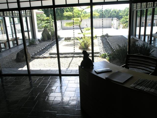
In back of me you see a beautiful Japanese rock garden.  This is the entrance to the beautiful Morikami Museum and Japanese Gardens. Through these glass doors, you will discover another world and go back in time to the early 20th century. It's right down the road from where Susan's parents live; in fact, this was the place that Susan and Rob visited when they first flew down to Florida in the 90's.  The museum was half the size it is now, but it was still lovely.

Actually, this museum started out as a Japanese farming community in 1904.  It was begun by Jo Sakai, who, after graduating NYU, returned to his hometown in Japan where he lead a group of 30 to 35 young Japanese farmers to what is now northern Boca Raton. They named their farming colony Yamato, which was an ancient name for Japan.


By the 1920's, the Yamato Colony, whose population had not grown, was falling short of their goals. Their crop experimentation all but failed and one by one, they left.  One settler did remain, however, and that was George Sukeji Morikami, who continued on here as a fruit and vegetable wholesaler.   Mr. Morikami donated the land to Palm Beach County in the mid-1970's when he was in his 80's.  He wanted to preserve the the memory of the those 35 young pioneers.

In 1977, the museum opened with the original building, the Yamato-kan being used for revolving exhibits.There is a beautiful bonsai exhibit right next to the Yamato-kan, which is styled as a Japanese villa. When you visit the building, you have to remove your shoes and tour the house with the paper slippers that the staff gives you.  It's one experience you never forget.

In 1993, the Morikami open its a new museum building, which is where I am sitting.  This building contains a  more than 7,000 Japanese art objects and artifacts, a theater, an authentic tea house, a library, classrooms, a wonderful museum gift shop and a cafe that serves great authentic Japanese food that overlooks the gardens.

In 2001, the Morikami expanded again, this time creating six different garden sites which represent changes in Japanese garden design over 1,000 years of Japanese history.  Each garden is different and lovely and worth the walk through, at least once.


The picture above and below is what you see as you enter from the parking lot.  This is the main entrance to the new museum building and the gift shop.  Every time Susan and Rob visited Florida each year, they would stop in here and buy souvenirs for everyone back in NY.  The cafe serves sushi and wonderful barley rice tea. 

Here is another picture of the rock garden down below.  This is a great place to come and relax and spend the at least one day enjoying the lovely exhibits, the great food at the cafe and stroll around the lovely gardens. Visit the Morikami's original building, Yamato-kan and discover the history of this beautiful and ever-changing museum.

Here is a link to the official site:

http://www.morikami.org/index.php?src=

here are some helpful links that I found on youtube that will explain more about the Morikami Museum

http://search.yahoo.com/search;_ylt=AuBiYWZwjVOpkIMvPJqP62SbvZx4?p=morikomi+museum+on+youtube&toggle=1&cop=mss&ei=UTF-8&fr=yfp-t-964

these show you some of the gardens and some of the activities and exhibits that are a part of this beautiful and ever changing museum.

this link on Youtube tells the history and shows you some of the beautiful gardens, describes their ever changing exhibits, takes you through their library, gift shop and cafe. Enjoy !

http://www.youtube.com/watch?v=TVhXvWTwM5Q&NR=1

Friday, October 15, 2010

Arthur R. Marshall Loxahatchee National Wildlife Refuge, Boynton Beach, Florida

Here I am at the Loxahatchee National Wildlife Refuge Boardwalk at the Visitor's Center.  Not too far in we saw a family of baby alligators and their mom which I will show you a bit later.

The refuge itself is part of the Everglades and part of the Arthur R. Marshall Foundation since 1998. They are dedicated to preserving the Everglades and its inhabitants, the Florida panther and the alligator, both listed as endangered species.

Loxahatchee is only a small part of the Glades.  It begins as far north as Kissimee, draining through Lake Okeechobee and filtering into southern Florida.  According to author Majorie Stoneman Douglas, the broadest point of the Everglades or "River of Grass" measures 60 miles across but is only a few feet deep.

To Florida's first settlers however, the Everglades was considered a worthless swamp.   In 1881, a Philadelphia businessman named Hamilton Disston purchased four million acres of the Everglades which he promised to drain and turn into profitable farmland, but died before he had the chance.  In 1904, Governor Broward initiated the drainage by constructing five major canals, all of which exist today. 

Here I am at another part of the refuge, one of the levees. There is a boat launch to my left and very often you can see an air boat pass by here.

In 2000, the Florida legislature recognized the need to preserve this marvelous ecosystem and ratified the Comprehensive Everglades Restoration Plan, a 30 year plan to restore the Everglades.  In 2008, land was purchased to provide a missing link from Lake Okeechobee to the Everglades. This program, along with the U.S. Sugar Corporation selling off its 187,000 acres of farmland (a longtime staple in the area) will help to revitalize the River of Grass.  I also forgot to mention that the Everglades is the backup water system for three million south Floridians.


Hopefully, you can see the head of George, the 13 foot alligator. That's the name the volunteers at the Visitor's Center gave him.   He was hanging out under the boardwalk and Rob got a great picture of him.  You can see my shadow at the top before Susan grabbed me away.

The levees are divided into different areas and most of the alligators can be spotted here along the Marsh Trail.  This is the place to go to find a gator and you won't be disappointed. Each and every time we've stopped by, we always catch one or two or three.  There are also beautiful birds and wildlife can be seen as well.  You can also climb to the top of an observation deck and spend hours watching and listening to everything around you.

By the way, there is plenty to do at the Visitor's Center.  You can take a virtual air boat ride, learn the history of the Everglades and discover the Everglades at night. There is also a lovely butterfly garden as you drive in.  The volunteers are friendly and informative and keep you in the loop as to the comings and goings of the refuge.  There are boardwalks you can follow such as the Cypress Swamp trail where I'm seated above.

Well, here comes the part I was telling you about, the babies and their momma.  You can see the top of Mom's head if you look closely, she's right in back of the feeder. Above is a picture of one of the eight baby gators.

As usual, here are links to other sites which will talk about the Everglades in more detail:

This is the Wikipedia article:

http://en.wikipedia.org/wiki/Loxahatchee_National_Wildlife_Refuge


The official site:
http://www.fws.gov/loxahatchee/


The Arthur R. Marshall Foundation Site, where I found the history of the Glades.
http://www.artmarshall.org/

And the Everglades Trail:

Saturday, October 2, 2010

Historic Poole Forge, Caernarvon Township in Lancaster County, PA


Here I am sitting on the covered bridge at Historic Poole Forge.  Built in 1859 for twelve hundred and nineteen dollars after sixty two citizens from Caernarvon Township signed a petition requesting a bridge to be built over Conestoga Creek just a year before.

  It was recommended that the bridge should be built without a roof so that the sparks from the forge wouldn't set fire to the bridge.  It was also recommended that the location of the bridge should be 90 feet from the south corner of the Forge Coal House.  Since 1859, there were a number of repairs made to bridge, one in 1889 for new side boards and another in 1916 for a roof. In 1961, the bridge transferred from the state to the township to the present owner.  In 1980 it was designated by the National  Register of Historic Places and in 2005 it became part of the Caernarvon Township for inclusion into the park  In 2007, floor boards were replaced, sensor lights were installed and  the stone abutments reinforced.  Since 2006, the bridge is decorated every Christmas by the Theodore Burr Covered Bridge Society, a group of covered bridge enthusiasts formed in 1959.


The Paymaster's House

The Iron Master's House
 This is the Tenant House, just one of the historic houses at Poole Forge, which was just that.  It was built by Welsh immigrant, James Old in the mid-18th century and just one of the many forges that dot the area.   The forge itself was still standing in the early 1900's and most of the houses that stood inside the forge are now used for offices and guest houses.  The Paymaster's House has been leased to the Churchtown Bed and Breakfast, Now known as the Covered Bridge Cottage, it is offered to guests with or without pets.   

A large wooden pavilion can be rented.for parties and large groups.  You can walk through the spacious grounds if you are in the mood to do so.  

As usual, I'm including links to these sites which will give you more information regarding Historic Poole Forge:

 This article explains the history of Poole Forge in detail and the article that I borrowed some of the pictures from.

 http://readingeagle.com/article.aspx?id=245858

 Here is the Historic Poole Forge site which goes into more detail about the covered bridge. 

http://historicpooleforge.org/about/ 

I just discovered this wonderful site.  It's a overhead shot of Historic Poole Forge showing the park and the exact locations of each house.  There are some beautiful pics to accompany the site. Enjoy ! 

http://loc.alize.us/#/geo:40.133159,-75.979890,17,k/ 


Sunday, September 26, 2010

The Booker T. Washington Summer House, Fort Salonga, NY


 This modest house that I am sitting in back of was the summer home of Booker T. Washington from 1911 until 1914. The house, although unoccupied since the 1990's, has had local designation status since 2005 and is nominated for the National Register of Historic Places. The property was bought up in 2007, the new owner unaware of its historical status.  His idea was to tear down the existing house and build a brand new retirement home in its place.  When the owner discovered the historical status, he petitioned the Town of Huntington to waive it. A fight to save the house from demolition ensued and in 2009 the owner withdrew his petition.
The house is now on the endangered list as of 2010.  Situated on a cliff overlooking Long Island Sound, it is located in an erosion zone and is in danger of falling into the water. The plan is to move the house and to stabilize the shoreline but this still has to go before a public hearing to be approved.

The history of this historic house is just as fascinating.

It all begins with Theodore Roosevelt inviting Mr. Washington to dinner at the White House in May of 1907.  Two days later, he spoke at the Huntington Opera House.  This was Washington's first visit to the Huntington area.


Around this time, Mr. Washington was in the market for a summer home on Long Island and was offered to rent the Van Wyck farm in West Neck by its current owner at the time, Helen Van Wyck Lockman.  Mr. Washington accepted the offer and sent Mrs. Lockman a deposit four days later explaining that he would be using the place for the summer.  He spent four summers at the farm when, in 1911, decided to buy a house in a secluded spot in Fort Salonga, overlooking the Long Island Sound. 

There was no opposition to Washington purchasing a summer house here and participated in many local activities such as speaking at local churches and teaching Sunday school.

His stay in Fort Salonga was short-lived however, when he sold the house to Henry Brush in 1914.  He bought a house in Huntington Village from Brush as an investment.  He would die a year later in January of 1915 at the age of 59.   

After his death, the Fort Salonga property passed into the ownership of the Huntington Land Company in 1915 .  Eventually, the property would be bought up by a family from Forest Hills who used it as a summer home for many years until the death of the last member in 2005 when it was acquired by a local contractor. 

As for its current owner, he was urged to build his home closer to the road, behind the relocated historic home. 

Update:  9/7/11

We were riding around the neighborhood on Labor Day and paid a visit.  The entire area is all overgrown.  No one seems to be taking care of it.  There was some damage to the house due to the recent storms that we've had, but for the most part, it's still standing.  I am just wondering now if the current owner is just waiting for this house to collapse into ruin so he will be able to build on the property. 

Here are some of the links that will explain more on this historic house.

http://sites.google.com/a/friendsofthebookertwashingtonhouse.org/www/home

http://www.longislandpress.com/2009/07/16/this-house-is-history/

Here is an article from the New York Times, April 2, 1911

http://www.longislandgenealogy.com/BookerTWashington.html

http://www.longislandpress.com/2009/08/28/booker-t-washington%E2%80%99s-historic-home-safe%E2%80%A6for-now/

Saturday, September 25, 2010

Mt, Washington, Mt. Washington Stage Line, Glen, NH, Cog Railway, Bretton Woods, NH

This is the start of something great. The Mt. Washington Auto Road.   Unfortunately, the mountain is covered over in fog which it is most of the time. The weather up there is terrible, in fact it is often called the "world's worst weather."  The weather can change in a matter of minutes.  I know, I've been up there with Susan and Rob.  I can tell you a story that was handed down to me.  Years ago when Rob and Susan first visited the White Mountains, they waited all week for the fog to burn off.  On their last day in the area, Rob called to see if the weather had actually cleared up and was told that it was finally clear.  That's when  the two of them jumped in their car and made the long 45 minute trip from one end of Kangamangus Pass to the other end only to find out that it had gotten foggy again.  They did go up that day, but have been to the top of Mt. Washington many times since then.

Here I am buying my ticket for Mt. Washington Stage Line.  Around the time these pictures were taken, Susan and Rob had a Saturn, which was not allowed to go up the Auto Road, so we opted for the Stage Line.  You can spot me on one of their vans down below.

The stage lines going up the Auto Road were just that: horse drawn coaches used to climb this perilous road upward to the summit. These days, the stages are vans with trained drivers to reach the summit safely and comfortably.    This is a steep and treacherous road and not everyone wants to make this climb by car. 
Once atop the summit however, you have to wait 30 minutes until the stage returns to take you back down to the bottom. 

 The Mt. Washington Auto Road started with wheat coming down from Canada. There was a need for a huge crop to be transported, but there was no ice free port available so a railroad line was built from Montreal to Portland, Maine  It passed through the small town of Gorham and opened up the east side White Mountains to the tourist trade. 

 Finally at the top.  

 Another way to reach the top, if you don't want to take the car, is the Mt Washington Cog Railway, which they had taken on one of their trips. Susan and I are posing in front of the exact same car we took a few years previous to this trip.  It was funny that our stage reached the the top the same time as this Cog Railway car.

According to the Cog Railway site, this is the first mountain climbing car of its kind.  

  The train car is pushed upward by a coal powered steam engine on a three mile long track making this the second steepest mountain climbing train in the world. . It is the only train track built entirely on a trestle. 

Well, here I am safely back down from the top of Mt. Washington and I'm wearing my button to prove it.  What a great trip we had.


As usual, here are the links:

The Mt Washington Auto Road site contains the history of the road and shows a video of the opening.  It's an interesting site and worth checking out

http://mountwashingtonautoroad.com/Page-16.html

the Cog Railway site

http://thecog.com/index.php


Oh and one more picture.  I couldn't end this blog without  you seeing Mt. Washington, so below is a picture of me with a clear shot of the mountain in the background.  It's the snow capped mountain directly behind me.  The hotel that you see is the Mt. Washington Hotel.


Here is a link to a Wikipedia article on Mt. Washington.  Enjoy!
http://en.wikipedia.org/wiki/Mount_Washington_%28New_Hampshire%29

and another link to the Mount Washington Observatory where you can see pics of the observatory and pics of the mountain from various locations:

http://www.mountwashington.org/

webcams

 http://www.mountwashington.org/weather/cam/

and my favorite site, the Mount Washington Hazecam which is set up in back of a school in Conway, NH. 

http://www.hazecam.net/mtwash.html